CSIRO flies high to delve deeper into Narrabri faults
CSIRO researchers will take to the skies to shed light on subterranean structures deep below the Pilliga State Forest in the Narrabri region of New South Wales.
The airborne electromagnetic survey will provide new information about the top 400 metres below ground surface, which to date has been studied in a limited fashion due to access restrictions associated with dense bushland.
Results of airborne geophysical electromagnetic surveys will be integrated with geochemical modelling in the latest CSIRO research project designed to better understand connectivity between coal seams and overlying aquifers.
And in parallel, new additional research will be undertaken by CSIRO scientists to develop independent groundwater modelling and predictive analyses. These analyses will help inform coal seam gas (CSG) groundwater impact assessment and regulatory monitoring and management in the Narrabri region
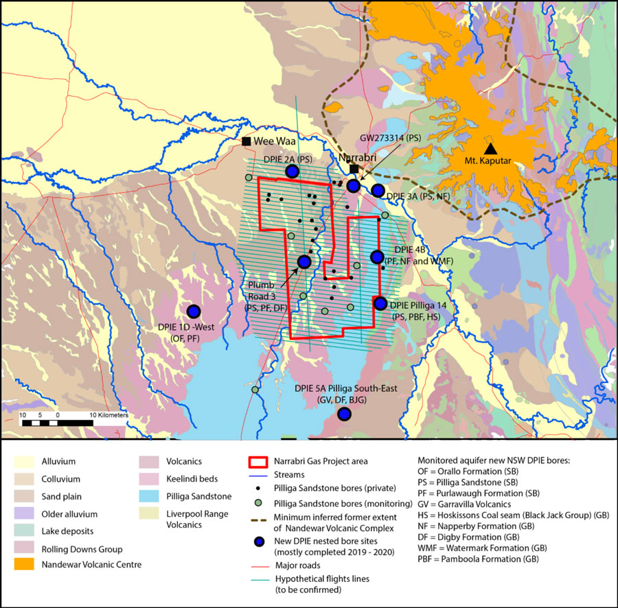
New NSW DPIE groundwater monitoring bores (drilled mostly between 2018 and 2019) in the wider Narrabri Gas Project area available for sampling (Raiber et al., 2022) and a hypothetical grid of airborne electromagnetic (AEM) survey lines (black lines). SB refers to bores screened within the Surat Basin, and GB corresponds to bores screened within the Gunnedah Basin.
These new projects build on a series of previously completed CSIRO geophysical and groundwater modelling research projects which address public concerns regarding potential impacts on groundwater from proposed gas resource development.
The new geophysical and geochemical research project, Geochemical modelling and geophysical surveys to refine understanding of connectivity between coal seams and aquifers, is designed to fill data gaps identified in previous research.
The project employs a multi-disciplinary approach that combines existing data with targeted acquisition of new hydrochemistry, geochemistry, and airborne geophysical electromagnetic survey data.
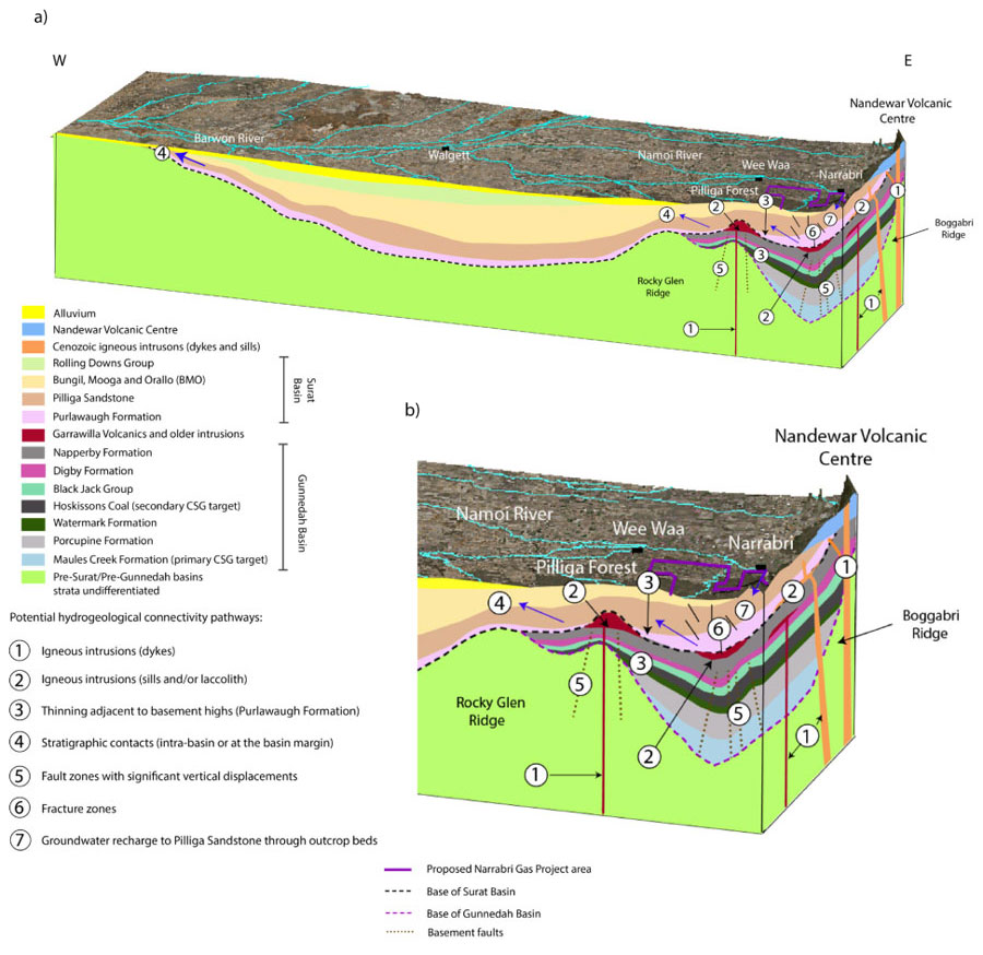
a) Block diagram showing the conceptual hydrogeological connectivity pathways in the central/northern Coonamble Embayment (revised from Suckow et al., 2019); and b) zoom into the eastern part of the block model (Raiber et al., 2022).
The most up-to-date research in this area, described in the recently released CSIRO report Assessment of faults as potential connectivity pathways provides the most comprehensive multi-disciplinary investigation of the region to date.
Using a combination of different geophysical methods and environmental tracers CSIRO scientists assessed the continuity and performance of aquitards separating shallow aquifers and coal seams within and near the proposed gas project development area south-west of Narrabri.
- For more information on the latest research being conducted through CSIRO’s Gas Industry Social and Environmental Research Alliance (GISERA): https://gisera.csiro.au/
Who are the GasFields Commission Queensland?
Established as an independent statutory body in 2013, the Commission’s purpose is to manage and improve the sustainable coexistence of landholders, regional communities and the onshore gas industry in Queensland. The Commission manages sustainable coexistence in petroleum and gas producing regions of Queensland, and will continue to do so as the industry expands into new and emerging basins.
Our vision is to achieve thriving communities in areas of gas development that are free from discord and supported by well-informed, respectful and balanced stakeholder relationships.
One way the Commission is endeavouring to realise this vision is by providing transparency and independent assurances that the onshore gas industry is appropriately regulated and held to account when needed. This in turn will help cultivate sustainable coexistence, whilst ensuring community and landholder confidence in the regulators and gas industry increases.
Drawing on its wealth of experience in the development of the gas industry and by collaborating with other relevant entities, the Commission provides a range of support to communities and landholders, primarily through education and engagement. These education and engagement activities occur with individual landholders via Commission facilitated webinars, information sessions, publications (The Gas Guide, Shared Landscapes Reports), face-to-face meetings and public workshops.
It should be noted that the Commission does not engage in individual negotiations between landholders and gas companies, but rather provides communities and landholders with the information and support they need to make informed decisions and achieve good outcomes.
Latest Articles
Proposed legislation to expand GasFields Commission’s remit
![]()
What are your views on the onshore gas industry and GasFields Commission Queensland?
![]()
Coexistence challenges and opportunities
![]()
Join the conversation to enhance coexistence in Queensland
![]()
Corrigendum to the report: Review of the Regional Planning Interests Act 2014 Assessment Process
![]()